Sistan and Baluchestan, Iran
MonaPres Web Platform
MonaPres Phone Application
MonaPres Monitoring Center
Previous
Next
Sistan and Baluchestan province, Iran

Inherently, nature has a completely integrated essence. Natural disasters such as earthquakes, floods, droughts and so forth have unbelievable effects on human-environment security. Particularly, droughts as a silence war resulting in successive impacts including prolonged shortages in the water supply, whether atmospheric, surface water or ground water, and also degradation of ecosystem and biodiversity.

Droughts could cause reduction of soil moisture, destruction of organic materials in soil, degradation of vegetation coverings and reduction of biomass. To delineate it more, drought could cause harmful effects on agricultural production; consecutively, socioeconomic developments may face several problems and finally food security will turn into an overwhelming crisis. Moreover, natural soil will face successive erosion resulting in spreading dust hotspots and finally leading to dusty storms. Low level of socioeconomic welfare, unreliable food security and dust storms will lead to a undesired social action called migration which create miscellaneous conflicts, whether governmental, regional or people themselves.

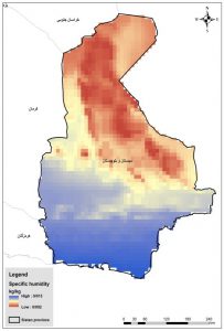
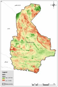
Obviously, drought cannot be prevented. However, drought could be monitored, assessed and predicted to develop new planning and scenarios to cope with its harmful effects. Drought is a looming threat for many people of Iran which is a country in the arid and semi-arid region. In this research Sistan and Baluchestan province and the surrounding region, with a specific climatic condition and faced with permanent droughts, has been assessed for effective and sustainable water policies.

In this research Sistan and Baluchestan province and surrounding region which has a specific climatic condition and faced permanent droughts has been assessed as an important vision of this province’s water policies.

Main Visions

  • Providing a multiple Near Real-Time drought Assessment and Prediction system
  • Making a platform for management and adaption to future floods and droughts (as the main natural hazards)
  • Providing required weekly, monthly, seasonal and annual reports for decision and policy makers
  • Founding the Zahedan’s Center for Climate forecast and decision making
  • Tracking Land use and land cover within the basin and its upper basin

MonaPres Main Products

  • Developing an accurate localized Product for Precipitation data
  • Identifying the most suitable climatological data centers
  • Establishment of the first Drought Monitoring and Prediction System
  • Providing a high resolution for the short-term and long-term accuracy of precipitation and temperature forecasts

More Details

Air Temperature

For daily temperature data, MERRA 2 dataset is used at a 0.5° spatial resolution over the study area. In this regard, the temperature data is gathered since 1980 with NetCDF format. The historical data shows that the average temperature in this region varies from 12.4 to 28.1 centigrade degrees.

COPERNICUS dataset is used to estimate daily specific humidity data over the study area (at a 0.25° spatial resolution). The data is collected during the period of 1979-2019 with NetCDF format.

Specific Humidity
Soil Moisture 10 cm

Soil moisture as the water content of the unsaturated surface soil has significant role in agricultural drought monitoring. Satellite soil moisture measurement is a prevalent tool for providing better sight of water resources management. Here, for soil moisture, GLDAS dataset is used at a 0.25° spatial resolution over the study area. In this regard, the required data is gathered since it provides data with NetCDF format.

The soil/land vegetation status can be nominated as a holistic representative of the drought monitoring condition. In fact, the impact of all the important parameters in the detection of drought incidence, including precipitation, soil moisture, agricultural activities, etc. have direct effect on vegetation. The Normalized Difference Vegetation Index (NDVI) is a simple graphical indicator that can be used to analyze remote sensing measurements and assess whether the target being observed contains live green vegetation or not. NDVI always ranges from -1 to +1. Here, MODIS products is used to estimate density and severity of NDVI index over the study area (at a 250 meter spatial resolution). The data is collected during the period of 2000-2019 with NetCDF format.

NDVI
Share on email
Share on linkedin
Share on whatsapp
Share on telegram
Share on twitter